
Flagstaff Singletrack Trail Maps
For the best maps of the trails in the Flagstaff Area, check out the info below.
Note: None of the maps are complete and some old trails that are now closed currently show up on this map. Additionally there are several 'hidden' trails that are not on any of the maps. Don't get lost... stay on marked trails.
Open Street Map project - Cycle version:
For the most complete maps, check out: http://www.openstreetmap.org This site has almost every trail listed and is constantly being updated.
Be sure to have the cycle layer turned on.
Most of the Singletrack trails west of and including Schultz Creek trail have been put in by Dirt Bikers and those trails are also largely maintained by Dirt Bikers, so PLEASE don't complain against our motorized friends - Mountain bikers, hikers and horse riders all get to use these trails because of Dirt Bikers!
Sedona Mountain Bike Trail Maps
When riding in Sedona, stay on trail and/or slick-rock. Riding off trail, though legal mostly, is bound to get you some thorns in your tires. I literally had about 50 thorns in one tire from just a short ride off trail.
Don't hurt the trails:
A common mistake hikers and bikers make is piling rocks along the edge of a trail as a border.
PLEASE DO NOT do this. It causes water to run down the trail, rutting it out (blue line below).
It is much better just to let the water flow off the side of the trail.
Pictured here is the Lower Brookbank trail in Flagstaff.
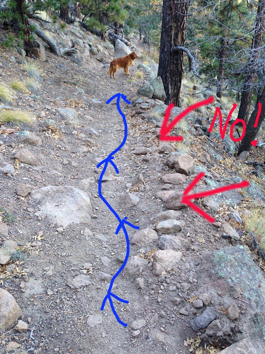
If you see rocks stacked like this on the downhill side of a trail, DO NOT add to them.
In fact, in most cases, you can help save a trail by removing those rocks.
Sustainable trail design includes "Full Bench" trails.
A "Full Bench" trail is out-sloped 5% to allow water to flow directly across the trail instead of down the trail.
To learn more, see IMBA (International Mountain Biking Association)
Here's a video that teaches the basics of Trail building (trail design stuff starts around 9:15)
| Bible Scholarship | Outdoors | Mark Haughwout | |
|---|---|---|---|
| About Mark | |||
| Contact | |||
| Terror Attack | Highwood Construction | ||
| Rock Island & KATY trail bike tour | Politics | ||
| Hiking in Flagstaff | |||
| MOTORCYCLES |
This Website and all content Copyright 2025 Mark S. Haughwout all rights reserved - Contact